 By John Hackett:
In 1988 the Iowa Department of Natural Resources (DNR) put into motion plans to create a 47 acre lake in western Plymouth County. The impoundment was to be called Deer Creek Lake. The project was completed in the late 1990’s, but without the lake.
In April of 1989 the DNR made public its plans to build five lakes in the state. These lakes were; Deer Creek Lake in Plymouth County, Shawtee Lake in Freemont County, Lost Grove Lake in Scott County, Whitewater Lake in Dubuque County, as well as Brushy Creek Lake in Webster County. The total cost of acquisition of property for, and the construction of the lakes was estimated at $26.5 million. The funding came from three major sources; the Iowa Fish and Wildlife Trust Fund, which is made up of hunting and fishing license money; the Iowa Wildlife Habitat Fee Fund, used to be called wildlife habitat stamp-it is now called wildlife habitat fee; and the federal Dingell-Johnson program, which is money collected as an excise tax on fishing equipment manufacturers.
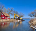
The property for Deer Creek Lake was purchased in seven separate tracts from willing landowners in the early 90’s. The dam for the lake was completed in late 1999 or early 2000 but never held sufficient water to create the proposed 47 acre lake. The loss of water was due to an unforeseen underground crack in the substrate. What water that was in the lake was drained in 2001 and large quantities of grout were pumped into the crack. Unfortunately this did not fix the problem. A similar attempt to fill the crack was made in 2002 also, with the same negative results.
No liability was placed by the DNR on any of the contractors involved in the lake construction. All of the geological studies conducted on the area before the project started indicated success. The DNR felt no one could have foreseen the problem. At this time the DNR does have a work request submitted to fix the substrate crack in Deer Creek Lake. No time frame for completion or possible solutions to the problem were given however. It is likely the problem will never be addressed to create the 47 acre lake.
Today the area is open for public use and is known as Deer Creek Wildlife Management Area (WMA). Deer Creek WMA is located one mile west of the intersection of Butcher Road and Hwy K18 in Plymouth Co. The area lies just east of the Broken Kettle Grasslands and north of the Five Ridge Prairie.
Deer Creek is open to public hunting, fishing and other compatible recreational uses such as bird watching, hiking, etc. The area encompasses about 1,035 acres and is composed of primarily of warm and cool season grasses interspersed with agricultural food plots and small areas of trees and brush. The goal of the DNR is to manage this area to benefit grassland dependant wildlife. The non-native grasses are managed by controlled burning and noxious weeds are also controlled.
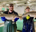
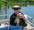
What was to be the 47 acre Deer Creek Lake now amounts to about a four to five acre farm pond. This is one of eight total ponds in the public area of Deer Creek WMA. The other seven are remnants of previous water shed improvements in the area before the Deer Creek project started. All of the ponds are from one to five acres in size. The larger of the ponds were at one time stocked by the DNR Fisheries Dept., which means they should harbor bluegill, largemouth bass and channel catfish.
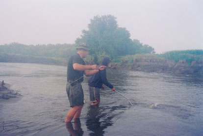
Even without the 47 acre lake, Deer Creek WMA sill offers anglers excellent fishing opportunities. The main lake does have a concrete boat ramp, but most times the water is far short of it. Smaller boats can however be carried a short distance to the water. The pond on the very northern edge of the property is accessible from the road. Anglers must travel by foot to access the other ponds.


I can remember when they first started on Deer Creek. A few of the “Old Timers” in the area tried to tell the DNR that “It ain’t gonna work..” Even showed them where the “seasonal” springs were (the cracks they say were unforseen). Their knowledge and experiences with that chunk of land was discounted and thought to be old fart belly acheing, interference, and resistance to the project. It wasn’t. It was even suggested by some of these “Old Farts” that instead of the 47 acre lake, make and/or improve the 5 to 7 ponds in areas known to hold water, along with trails to get back to the interior ones not near the access roads. This suggestion was tossed into file 13. Looks to me like they might want to dig that suggestion out of the trash and save the taxpayers some $$ and give them a more viable hunting/fishing area.